
SEVERE CONVECTIVE WATCH - SAT 30TH DEC 2023
Issued 2023-12-30 09:45:57
Valid: 30/12/2023 0900 - 31/12/2023 0600
Forecast Details
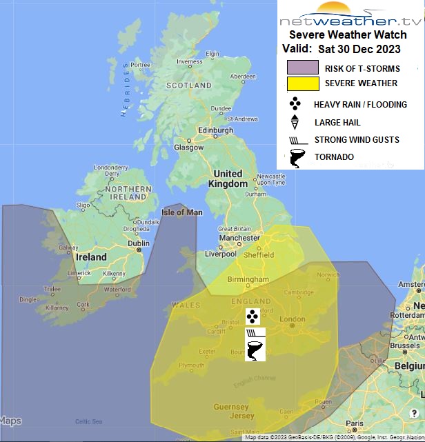
... SOUTHERN BRITAIN SATURDAY EVENING / OVERNIGHT ...
- Isolated 60-70 mph convective wind gusts
- Isolated brief tornadoes
- flash-flooding
- lightning
Upper low and collocated deep surface low to the west of Ireland will drift east to be over NW Ireland by midnight, the surface low weakening. An occluding frontal system will move north and east across northern and western Britain during the day, bringing outbreaks of rain across northern and western areas, snow over northern hills. The trailing cold front is of more interest in this forecast, a band of heavy rain along the front will cross the Irish Sea over to SW England, Wales and NW England this morning – where it will become slow-moving through the afternoon, as wave develops along the front. Some localised flooding issues possibly arising across the west as a result.
Most rainfall will be dynamic in nature during the day, though heavy at times. But through this evening, an upper-level shortwave trough rounding the base of the upper low approaching Ireland will move in from the SW and engage the cold front, causing it to surge eastwards across England. Increasing convection as the upper trough enhances ascent along the front and strong low-level winds parallel to the front will likely induce a long linear line squall of intense rainfall surging east. Very strong low-level jet winds could be brought down to the surface along the squall line through convective processes, producing localised convective gusts of 60-70mph. Strong low-level shear is forecast by convective-allowing models ahead of the cold front, so should more intense segments or Line Echo Wave Patterns (LEWPs) develop along the squall line, there is potential within gaps between the segments / LEWPs for strong vertical ascent of air combining with enhanced horizonal shear creating small circulations (misocyclones) which could produce brief tornadoes too. Localised flash-flooding is possible from the intense rainfall too.
Instability along the cold front may be too shallow for more than isolated lightning. However, following the cold front clearance, instability is expected to increase as colder air aloft arrives atop relaltively warmer SST, which will support heavy showers and some thunderstorms to follow the cold front across S Ireland & southern Britain overnight, with a risk of hail and localised flooding continuing.
Issued by: Nick Finnis
Issued by the Netweather forecast team whenever there is a risk of storms or severe convective weather, these discussion based and in depth forecasts will highlight the areas at risk and give an in depth description of the risk and the factors surrounding it.
Site Search