
To view your local snow forecast, type your city, town or postcode into the box below and select your location from the list.
Snow Forecast For
| Time |
|---|
| Temp | Wind | Wind Chill | 500-1000 hPA | 850hPA Temps | Precip | Snow Risk |
|---|---|---|---|---|---|---|
Local Information For City of London
Moon:

Sunrise:
Sunset:
Sunset:


Snow Forecast Information
You may not be familiar with a couple of the items within the snow forecast, the first one 850hpa temps is the temperature at approximately 1.5km above the ground. Generally this temperature needs to be at -5°c or below for snow to be likely. The other term is 500-1000hpa, this is a measure of the height or 'thickness' between these two points in the atmosphere (HPA is a measure of air pressure, so these points move up and down dependant on conditions). In general for snow to be likely, this value needs to be showing 528dam or less.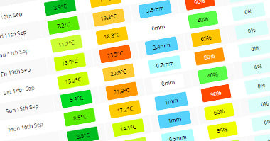
Site Search